
[an error occurred while processing this directive]

Today@Sam | Headlines | Calendar | Experts | Notices | Archives | Search
War of 1846, Early Maps
Featured in Museum Exhibits
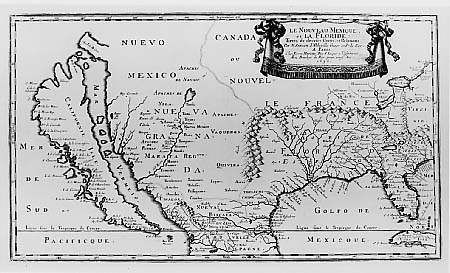 Early maps of the Southwest had inaccuracies such as mountains in the wrong place, the Mississippi flowing through Texas, and California depicted as an island. |
"Invasion Yanqui" is a photographic exhibition on the Mexican War of 1846. From this war so seldom remembered, the United States emerged with one-half million square miles of new territory, a classic essay on the moral responsibility of citizens--Thoreau's "Civil Disobedience"--and a well-trained corps of officers.
Robert E. Lee, Ulysses S. Grant, "Stonewall" Jackson, and William T. Sherman, among others, gained their first combat experience in Mexico.
"This exhibit will give the viewers a rare opportunity to reflect upon the war that determined the size, shape, and wealth of the United States for the next century," said Dave Wight, curator of exhibits for the Museum.
The exhibit was created by the Texas Humanities Resource Center in collaboration with the Jenkins Garrett Mexican War Collection of the University of Texas at Arlington Library.
It includes color photographs featuring art, original lithographs, artifacts, maps and documents, and texts in English and Spanish that narrate the war for possession of all of Texas and the Southwest.
A second exhibit, "Crossroads of Empire," also opens Friday. It consists of photo panels based on a major collection of maps which made a two-year tour of the Southwest under sponsorship of the Amon Carter Museum.
The exhibit contains a number of geographical surprises, because most early map makers were merely guessing about the Southwest. Some maps depict the Mississippi River flowing through Texas before heading to the Gulf of Mexico. Others show mountain ranges in plains regions, and several insist that California is an island.
Although the Spaniards had explored the Southwest, said Wight, they kept their information to themselves and printed very few maps. Thus other map makers had to rely on rumors, stories told by explorers, and earlier, often inaccurate maps.
The Walker Education Center is located at 1402 19th Street. Regular hours for viewing the exhibits are 9 a.m. to 4:30 p.m. Tuesday through Sunday. Both exhibits run through March 15. Admission is free.
For more information on the exhibits call Wight at 936.294.1832 or refer to the Museum's Website.
- END -
SHSU Media Contact: Frank Krystyniak
Jan. 29, 2002
Please send comments, corrections, news tips to Today@Sam.edu
This page maintained by SHSU's Office of Public Relations
Director: Frank Krystyniak
Communications Coordinator: Julia May
Located in the SHSU University Advancement Building
Telephone: 936.294.1836; Fax: 936.294.1834